Kadal Map
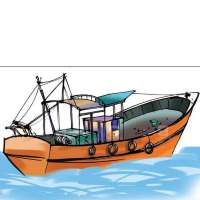
The best App which helps fishing boats to record their fishing tracks and to find stones under sea..
Try the App free for 1month.


The best App which helps fishing boats to record their fishing tracks and to find stones under sea..
Try the App free for 1month.

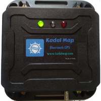
The GPS receiver brings you the best of both worlds by combining GPS and GLONASS receivers with Bluetooth wireless technology so you can enjoy precise position information on Kadal Map.
LED Indications
* Green = Power Indication.
* Yellow = Connected to Kadal Map.
* Red = Blinks when connected to Satellite.

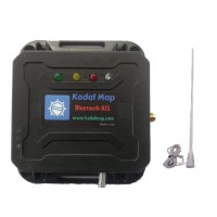
This Dual channel AIS receiver allows you to view all Ships and Boats with AIS Transmitter around you on Kadal Map.
Features
* Dual channel AIS receiver.
* Receive AIS Signal from Ships and Boats/Buoys simultaneously.
* Up to 50 nautical miles receiving range.
* You can see all details about the ship (Name, Location, speed, Compass, Size of Ship, Country, Destination port..
* Simple to set up, just plug in and use..

Display the Map from openstreetmap, which gives the clear mapview of seashore.

Display marine chart with depth in meter.

Easy to view the seashore and harbour entrance with this satellite map.
Just open the App and its ready to use with Complete OFFLINE maps
You can store unlimited waypoints/stones, easy to select with different images.
You can store unlimited tracks with different colors. You can store the catched fish details with the Track.
View the Map in 2D and 3D.
Users can download Wind and Sea Current for 10days and use it offline on sea.
Users can create their own Route, within few seconds.
Users can backup their stones and tracks to the cloud, so they can reterive it when they loss their phone/tab.
Users can easily share their tracks and stones to friends. (Only this feature and Backup feature needs Internet)